
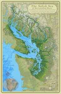
What is the Salish Sea?
Unless you are a local, the “Salish Sea” might not be the first to come to mind when listing other well-known seas around the globe. This is likely because the name Salish Sea wasn’t actually recognized until 2009 after being proposed as a name 20 years earlier. “Salish” is to honor the Coast Salish tribe who were the original people to settle along this region. The name was created to define the full, expansive body of water nestled between both the United States and Canada. This encompasses a complex network of interconnected waterways including the Strait of Georgia, the Strait of Juan de Fuca, and the Puget Sound. Covering over 4,600 miles of coastline and including over 400 islands, which are mostly grouped into either the Gulf Islands, San Juan Islands, or Discovery Islands, the area is booming with wildlife activity and natural geological wonders.
Geological Origin
The shaping of the Salish Sea began over 150 million years ago with a collision of tectonic plates causing a sizable depression, known as the Georgia Depression, along the low lying coastal plains. Over time, lava flows, volcanic eruptions, and the further collisions of tectonic plates continued to lay the groundwork for the Salish Sea’s formation. Even some of the islands we see today are part of ancient underwater volcanoes that have since gone extinct. This evolved the geological make-up of the land into a very diverse formation of various forms of sedimentary and igneous rocks including limestone and granite with very porphyritic textures.
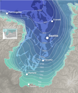
The landscape continued to get carved out throughout the Ice Ages. Massive ice sheets slowly advanced and retreated squeezing between the Cascade and Olympic Mountains on at least four major occasions. These sheets scoured the land, deepening the valleys and rivers, depositing an assortment of clay, sand and rocks, and creating dramatic topography throughout the region. The last sheet, the Cordilleran ice sheet, covered what is now Anacortes in over 4,000 feet of ice! As the ice melted and receded, the rising sea levels filled these newly formed depressions with water, giving birth to the Salish Sea as we know it today.
The Cascadia Subduction Zone
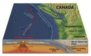
The geological marvels of the Salish Sea don’t end with glacial processes. The region is also influenced by the Cascadia Subduction Zone, a major tectonic boundary where the Juan de Fuca Plate is being slowly pushed beneath the North American Plate. This slow and inexorable process, known as subduction, results in intense geological activity, including earthquakes and volcanic eruptions.
Subduction has led to the formation of several underwater volcanoes and seamounts within the Salish Sea. One such prominent feature is the Endeavour Segment, a ridge created by volcanic activity that is part of the Juan de Fuca Ridge. These volcanic formations have played a crucial role in shaping the marine ecosystems within the Salish Sea, as they provide unique habitats for various species of marine life.
Hydrology and Oceanography
The Salish Sea’s hydrology is a complex dance of freshwater input and tidal flow. Numerous rivers, such as the Fraser, Skagit, and Snohomish, drain into the sea, carrying a significant load of sediments and nutrients. This influx of freshwater shapes the marine environment and creates a delicate balance between brackish and saltwater conditions.
The tides in the Salish Sea are also a remarkable phenomenon, with some of the highest tidal ranges in the world. The interaction between the gravitational forces of the moon and the sun with the sea’s intricate topography results in tidal currents that continuously shape the coastline and the underwater landscape.
Biodiversity and Ecosystems
The geological diversity of the Salish Sea has given rise to a rich array of ecosystems, making it one of the most biologically diverse regions in the world. The waters are teeming with a wide variety of marine life, including fish, marine mammals, invertebrates, and seabirds.
Salmon, particularly Chinook, Coho, and Chum, play a vital role in the region’s ecosystem and cultural heritage. These remarkable fish species are anadromous, meaning they spend part of their life in freshwater rivers before migrating to the open ocean and returning to their birth rivers to spawn. This migration not only sustains the delicate balance of the marine ecosystem but also supports the livelihoods and traditions of the local people.
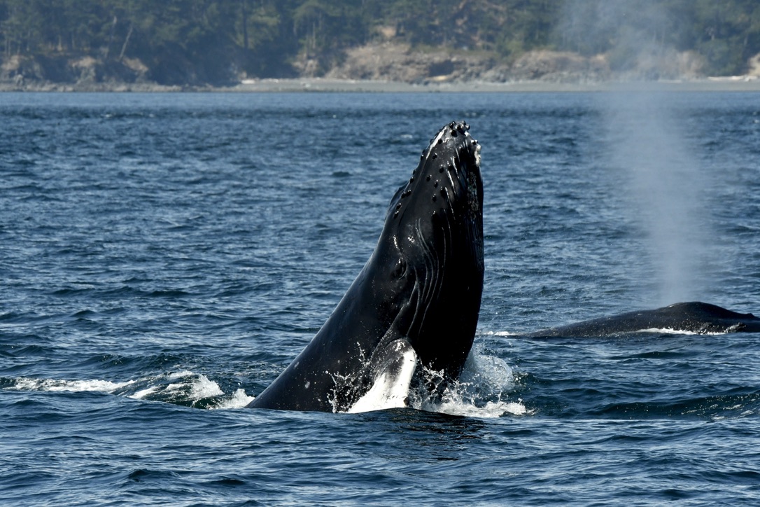
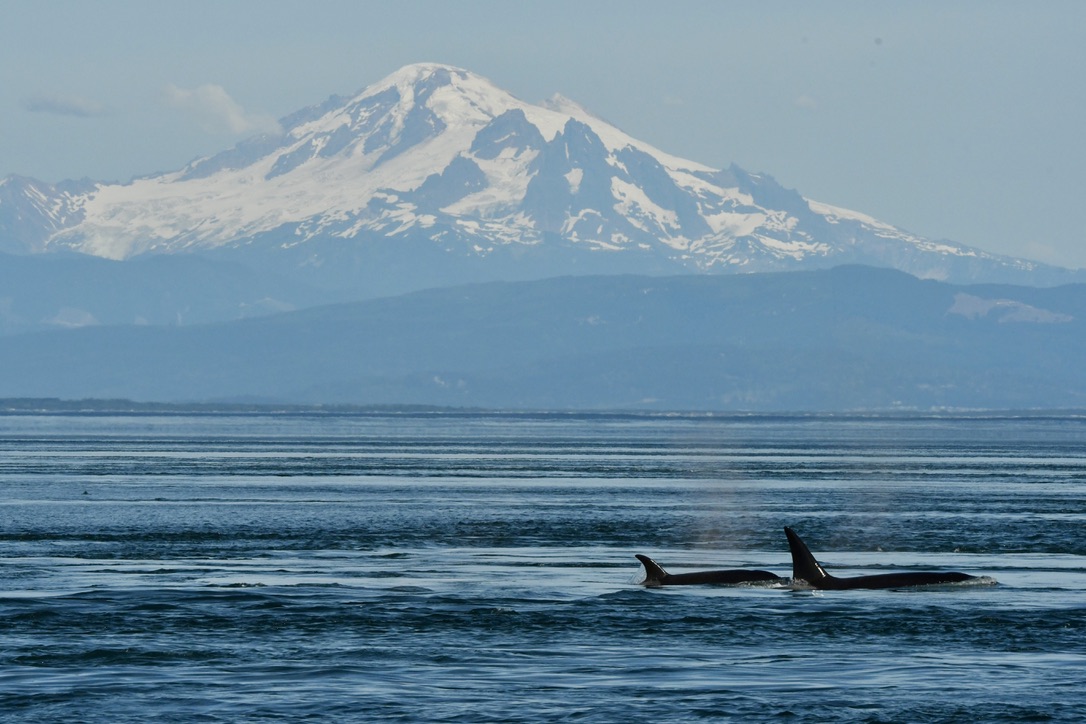
With an abundance of nutrient rich sediment from the rivers that blend into the Salish Sea, the food supply for smaller species all the way up to our largest marine mammals and whales is undeniable. There is a reason why the humpback whales we’ve identified return each summer to feed in the Salish Sea. Sometimes they bring calves, and more and more we are seeing new adults attracted to our waters as well! At the top of the food chain, the Bigg’s killer whales also know the plentiful opportunities for hunting their prey, who likewise are thriving off of smaller fish and krill.
The Natural Wonderland Today
The Salish Sea is a masterpiece of geological history and a natural wonderland showcasing Earth’s dynamic forces and an evolution of habitats. Preserving the delicate balance of the Salish Sea’s ecosystems is of paramount importance, as it sustains not only a vibrant array of marine life but also the cultural heritage and livelihoods of the communities that call its shores home.
Come join us for not just an incredible opportunity to observe whales and wildlife in this “happy place,” but also for an exciting boat ride that will fill your eyes with beauty and leave you in complete awe of nature.
References
Into the Salish Sea: How was the Salish Sea Formed?, 2023, Accessed on July 20, 2023, https://intothesalishsea.org/how-was-the-salish-sea-formed/
Encyclopedia of the Puget Sound: Salish Sea Survey, Puget Sound Institute, University of Washington, 2012-2023, Accessed on July 20, 2023, https://www.eopugetsound.org/articles/salish-sea-geographic-literacy-survey
Wikipedia: Salish Sea, Accessed on July 20, 2023, https://en.wikipedia.org/wiki/Salish_Sea#:~:text=The%20Salish%20Sea%20sits%20within,from%20about%2019%2C000%20%E2%80%93%2016%2C000%20BP.